Does POLO Support including Latitude and Longitude information?

For no other reason besides QRZ is very annoying, I think I need to start including Latitude and Longitude information in my logs. The TL;DR is even if you have grid square, county, and state correct in the log it will still default to your logbook settings for gps coordinates. This screwed me up as last time I did a POTA it was in Arizona, so now like 300 contacts show as being in Arizona.

Adif includes this as a field under <‘LAT:X’> or <‘LON:Y’> without quotes.

Thomas,

Not 100% on what you are referring to but I will state the following to see if I am close.

When you post a QSO to QRZ, QRZ will apply a lookup to both YOU and the the other station, it will ignore whatever you put in as name, grid etc, and replace these values with the QRZ data for the calls.

There is no way to switch this off.

On the other hand, LOTW does allow you to override your grid for the day/activation with the one you want it to be. As long as you set the override option in TQSL

Likewise, eQSL will apply the grid associated with your nickname and will throw an error if you try to submit a mismatch. The only way to store grids which reflect your true location is to close a profile for each location and set the grid. For most people this requirement is a pain and people do not try. I just add my true grid location to the eQSL Message.

We generally work grids. If, in some interfaces, you enter a grid, the centroid is calculated in lat/long and if you instead enter a lat/long, the grid is calculated by decoding the grid in which the lat/long is contained.

PoLo can be set to use 6 or 8 character grids for more accuracy. For some VHF and SOTA challenge activities, this is used.

Am I covering some ground on what you are talking about?

Alan

Hey Alan, thanks for getting back to me.

This is the post I made on QRZ and have not heard back from anyone on.

https://forums.qrz.com/index.php?threads/accidentally-left-logbook-settings-for-another-state-any-way-to-bulk-edit.978829/

The problem arose after doing a POTA in AZ. I updated my logbook settings to put the correct grid, updated Lat / Long, uploaded my file, and was good to go. I then came home, did a contest, and this is where things started to get messed up.

I failed to update my grid and lat / long, so when uploading my contacts from the contest (which doesn’t include grid info) it defaulted to what was in QRZ (which was AZ). More on this in a second.

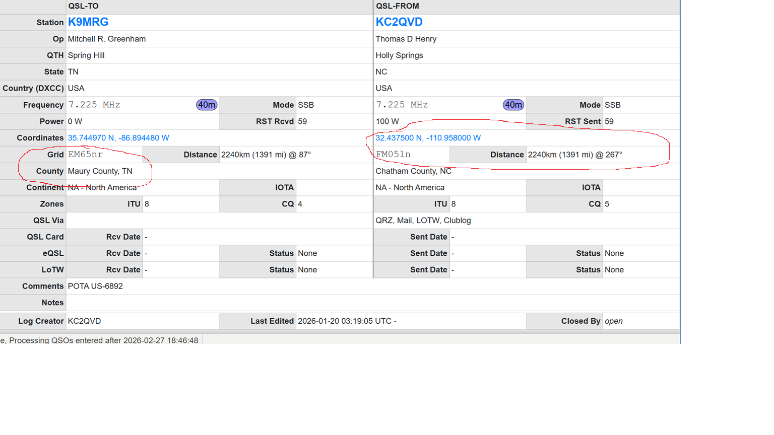
I then did a POTA and uploaded the full export which does include the Grid, County, all that fun stuff. Went to go look at a confirmed QSO and noticed “ah perfect, it does pull the info from the adif! And as I was about to click out, I noticed the distance between the two stations (TN and NC) could not possible have been almost 2k miles. Clicked on the Lat / Long values which took me to google maps and plopped me right into….AZ…. Because for SOME reason, even though I provided the Grid info, QRZ does not automatically update the Lat / Long which effects distance to other station. HOWEVER, oddly enough, if I went to edit the QSO and just simply “clicked” in the grid field, this updated to the correct coordinates. I didn’t type a new grid, didn’t edit anything, I just clicked the field. Really odd… Anyway, it was then that I realized the contest and POTA adif files I uploaded pulled the wrong info (since my logbook settings were still set up for AZ), and needed to correct it.

Well that sucks. Had to delete a ton of contacts and reupload, but anything used for an award couldn’t be taken back. So, sorry for anyone out there that has an AZ contact from me for those two activations. Can’t take it back.

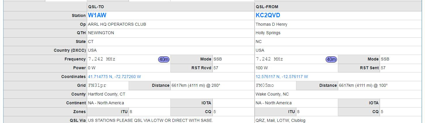
So anyway back to my problem. If I go right now and activate a park in PA and I make sure Ham2k has correct state, county, grid, all that info will populate into QRZ properly and all is fine and well, EXCEPT the Lat / Long information. I expect because when QRZ doesn’t have info in the adif file it pulls from your logbook settings page, which for me is my home address in NC. So this is more of a test to see if that is correct or not.

Am I being overly fussy? Absolutely. But if I can do what I can to make my information correct, I’d certainly like to.

OK - well I will make this comment.

We are all (each of us) a very small piece of the award puzzle. Sheer QSO volume at the end of day will cover a lot of “sins” for a lot of the hobby.

POTA is definitely focused on granting the awards it is focused on. Most other portable activities are likewise focused on their awards. QRZ is focused on its awards and if you don’t get one with this QSO, you will get it with the next one.

There are some work arounds for some systems as we have both highlighted.

I truly believe you are over thinking this. Do what is comfortable, what habits you find easy to achieve. Forget the dinky little stuff because the required time effort will crush you.

Alan

I get you and I agree to an extent. I guess my question would be could a feature be added to include the Lat and Long information in the adif file based on grid information? Similar to how the County field was added.

Just to be clear.. what QRZ award are you referring to that you are trying to grant to other OPs?

The county award does not use lat/long. The grid award is for 100 grids worldwide.

And when you say lat long, are you meaning MY_LAT/ MY_LON?

Alan

No award, this is just for me having the information be correct on QRZ. And yes I think it’s either MY_LAT / MY_LON or LAT / LON (not sure which one it is).

OK - sorry I am not trying to be difficult.

Forget about their LAT and their LON, you will never get YOUR recording of THEIR LAT and THEIR LON to count for anything since it’s what THEY give you that counts, not your impression of it. So if they say they are in AZ OTA and you record it as such, but you get their confirmation and it says NY, that’s it. You will never get AZ from that QSO. It’s what they give you in their confirmation that counts. (Sorry just trying to be very clear).

Next up is the MY_LAT and MY_LON. We, in the Ham world took to grids for the reason that it’s accurate enough without exposing our exact location to anyone. A lot of calculations including distance are made on the basis of grid to grid - be it 4 or 6 or 8 character etc. And in most cases that’s done by the distance between the centroids of the grids, not the lat/long. Some loggers offer a way to convert lat/lon to grid and also grid to lat/lon. So e.g. is you convert lat/lon to grid, then convert back, you will notice the lat/lon change from your “exact” lat/lon to the grid centroid lat/lon. But ultimately the distance is regarded as accurate enough to be from grid centroid to grid centroid.

Now, in the 2years+ that PoLo has been operating and many thousands of users submitting logs from it, to be the first person expressing a need for this data entry, it’s worth me getting to the bottom of it. So please be patient with my questions.

Can you just be a little clearer on what you had to “fix” / “Edit” on QRZ to ensure that the QSO was granted to the other OP correctly?

Alan

Edit: and if there is something that can be “fixed” by adding lat/lon, then you should not have to enter it yourself PoLo can do it for you.. which it could.

Here’s another thought..

Let’s say you are on a rove and you activate a park just down the road from me. I work you. And your QRZ is set to your home 1,000miles from me.

Whatever we both do to try and send a log entry to QRZ, you will never appear to me as a distance less than the 1,000miles away from me in the QRZ listing. My log will have you set to your QRZ location and that’s it.

I may record you as being n the park down the road and I may calculate your distance from me as 5 miles in my local logging program, but on QRZ you will forever be stuck at 1,000miles away.

Alan

PS, unless you go into QRZ, change your location prior to the activation, to reflect the park location, then leave it that way until my QSL comes through, then change it back….

So to be perfectly clear, I agree that I am being overly anal about this. I agree that QRZ does NOT require LAT / LONG to be correct for any awards. This is mainly me trying to prove that this should be easy to fix and QRZ never makes anything easy or clear to the end user. I wanted to see if this info was able to be included mainly as a way to say “hey QRZ, even if your system won’t work correctly, I can still format my data in a way that will be”. In my opinion, QRZ has a lot of work to do to properly log things like POTA, roving, operating in another state, etc without making it so much of a headache.

Highlighted below from my QRZ post. All grid and state and county info is correct, but coordinates and distance field are incorrect (No part of NC is 1400 miles from any part of TN). This is because my logbook settings still reflected AZ. Unless I update my logbook settings each time I go out into the field, this will always be slightly off as it will default the distance and coordinates to my home. The only way to fix this is either;

  1. Update my logbook settings everytime I want to go out (which I really do not want to do, I probably wouldn’t even do it for NC based activations).
  2. Include the LAT / LON info in the adif file so that it gets loaded for the contact.

I still don’t know if including those fields would update them in QRZ, I have to test them.

OK please test this, I will too. I am skeptical.

But as I say, QRZ is good for what QRZ does, and they are unlikely to make their environment “friendly” to roaming activities.

The same can be said about some of the major logging applications. It is certainly true of eQSL. and ClubLog doesn’t ever store YOUR grid per QSO, but does a wonderful job at what it does.

My personal log, on the other hand, does store the exact distances from me. wherever I am in whatever grid I am in, to where ever the other OP is - whatever grid they are in. So I’m anal as well but I gave up on getting other systems to do anything they don’t already do. It’s not worth the angst IMO.

Alan

Trust me, I totally understand your notes. This is strictly about proving a point.

FYI, I tested it and it was able to work correctly. Huzzah.

Created a dummy contact and updated MY_LAT and MY_LONG

image

Using the adif formatting for this field.

And this yields that info translating into QRZ (under my info on the right).

OK but you will still be totally at the mercy of what their QRZ record says for them, as far as accuracy is concerned. You may think that the distance is correct… but they may well NOT be where QRZ says they are. And the distance will be totally wrong and you won’t perhaps know it or be able to fix it.

On the other hand, if you know they are in a park, you can calculate it, but only your records will be correct as far as distance is concerned.

Alan

I have thousands of QSOs from these locations

If you had worked me in every one of them, and checked the QSLs for each on qrz, they would all have been from grid QF67bg. And if you had hunted me from your home location, the distance for every QSO would have been identical. Clearly this would be nonsense. But I do not change my location in QRZ so that’s how it will always be.

But in my log, the distance between me and you would be quite accurate regardless of you hunting me from your home (assuming your QRZ is correct) or you being in a park. Even my park2park distances with you would be accurate - but ONLY in my version of my log.

Alan